Unit 5 · Botany · 3 teaching hours · 22 min read
Vegetation
What the syllabus asks for 2
- Vegetation [2]: types of vegetation in Nepal; In-situ and Ex-situ conservation
- Natural environment, vegetation and human activities
Nepal is a small country — about 147,181 km², a little over a tenth of one per cent of the Earth's land — yet it holds about 3.2 % of the world's known flora. The reason is height. In a north–south line barely 193 km long the land climbs from 59 m in the Terai to 8,848.86 m at Sagarmatha, and every thousand metres of that climb cools the air by roughly 6 °C. A traveller walking from Birgunj to the Khumbu passes through as many vegetation belts as a traveller walking from India to the Arctic. This unit maps those belts, names the trees that mark them, and asks what Nepal is doing to keep them.
Three things, again and again: (i) name the vegetation zones with their altitude ranges and two indicator species each; (ii) differentiate in-situ and ex-situ conservation with named Nepali examples; (iii) list human activities that damage vegetation and the measures that repair it. Botanical names are worth marks — write Shorea robusta, not just "Sal".
5.1 Vegetation
Vegetation is the total plant cover of an area — all the plants growing there, described by their form and arrangement (forest, scrub, grassland, meadow) rather than by their names. Flora, in contrast, is the list of species found in that area. The Terai has a Sal-forest vegetation; its flora includes Shorea robusta, Terminalia alata, Mallotus philippensis and some 1,800 other flowering plants.
What decides the vegetation of a place
Four controls do nearly all the work in Nepal:
- Altitude. Temperature falls about 6 °C for every 1,000 m of climb. This single fact produces the belts described below.
- Rainfall and the monsoon. Nepal averages about 1,600 mm of rain a year and roughly 80 % of it falls between June and September. The east is wetter than the west — Taplejung gets about 2,000 mm, Baitadi about 1,000 mm — so eastern forests are evergreen and dense where western forests of the same altitude are drier and more open. The wettest station, Lumle in Kaski, records about 5,550 mm; Jomsom in Mustang, in the rain shadow behind the Annapurnas, records under 300 mm.
- Aspect — which way a slope faces. South-facing slopes are hot and dry and carry chir pine (Pinus roxburghii) and Quercus semecarpifolia; north-facing slopes at the same height are cool and moist and carry laurels, firs and rhododendrons.
- Soil and landform. Fresh river gravel carries khair and sissoo; the older, well-drained alluvium behind it carries Sal.
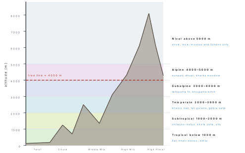
The vegetation zones of Nepal
| Zone | Altitude | Forest type and indicator species | Where in Nepal |
|---|---|---|---|
| Tropical | below 1000 m | Sal forest — Shorea robusta (sal), with Terminalia alata (saj), Anogeissus latifolia, Mallotus philippensis; khair–sissoo riverine forest — Acacia catechu (khayar) and Dalbergia sissoo (sissau) on fresh river gravel; Bombax ceiba (simal) savanna; khar-patter grassland of Saccharum spontaneum; tropical evergreen forest of Michelia champaca (chanp) in the east | Terai, Bhabar, inner Terai (Dun) valleys and Chure slopes — Jhapa to Kanchanpur; Chitwan, Bardiya, Shuklaphanta, Banke, Parsa, Koshi Tappu |
| Subtropical | 1000–2000 m | Schima–Castanopsis forest — Schima wallichii (chilaune) with Castanopsis indica (dhalne katus); chir pine forest — Pinus roxburghii (khote salla) on dry south-facing slopes; Alnus nepalensis (utis), a pioneer on landslides and stream banks | Mahabharat midlands — Kathmandu valley rim, Kavre, Dhading, Tanahun, Palpa, Surkhet, Dhankuta, Ilam; Shivapuri Nagarjun NP |
| Temperate | 2000–3000 m | Oak–rhododendron forest — Quercus semecarpifolia (khasru), Q. lamellosa, with Rhododendron arboreum (lali gurans); conifers Pinus wallichiana (gobre salla), Tsuga dumosa (thingre salla), and in the far west Cedrus deodara (devdar); Acer and Juglans regia (okhar) on moist slopes | Ghorepani and Ghandruk in ACA, Rara NP, Khaptad NP, Langtang, Ilam and Taplejung |
| Subalpine | 3000–4000 m | Fir–birch forest — Abies spectabilis (talispatra, Himalayan silver fir) with Rhododendron campanulatum (nilo chimal) beneath; birch Betula utilis (bhojpatra) in near-pure belts up to the tree line; Juniperus recurva (dhupi) in dry inner valleys | Sagarmatha NP, Langtang NP, Makalu Barun, Manaslu and Kanchenjunga CAs, Dhorpatan |
| Alpine | 4000–5000 m | Treeless. Alpine scrub of Rhododendron anthopogon (sunpati) and Juniperus indica; above it alpine meadow (kharka, patan) of Kobresia and Carex sedges with Primula, Gentiana and Meconopsis; the medicinal belt of yarsagumba, jatamansi, panchaunle and kutki | High Himal of all northern districts — Solukhumbu, Rasuwa, Manang, Mustang, Dolpa, Humla, Darchula |
| Nival (Arctic) | above 5000 m | Permanent snow, rock and glacier. Only mosses, lichens and cushion plants such as Stellaria decumbens, recorded as high as about 6,100 m | Above the snow line everywhere; Sagarmatha, Kanchenjunga, Api Nampa |
Behind the Himalayan wall lies a seventh kind of country. Upper Mustang, Manang, Dolpa and Humla lie in the rain shadow and receive only about 250 mm of rain a year — less than a tenth of Pokhara. The vegetation there is trans-Himalayan steppe, or cold desert: thorny cushion shrubs of Caragana and Lonicera spinosa, Artemisia, Ephedra gerardiana, with Hippophae (sea buckthorn) and willows along the streams and Juniperus indica on the better-watered slopes. Ground cover is thin and bare gravel is everywhere.
T–S–T–S–A–N — Tropical, Subtropical, Temperate, Subalpine, Alpine, Nival. The first five boundaries fall at neat thousands: 1000, 2000, 3000, 4000, 5000 m. Remember the tree line at about 4000 m — below it you can still find a forest, above it you cannot.
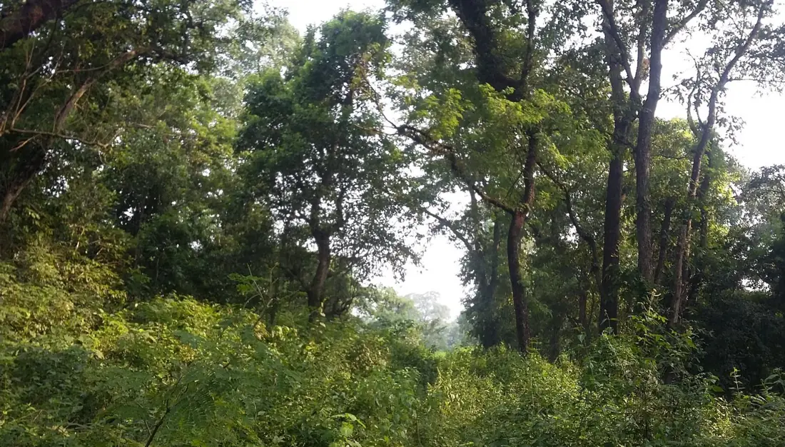
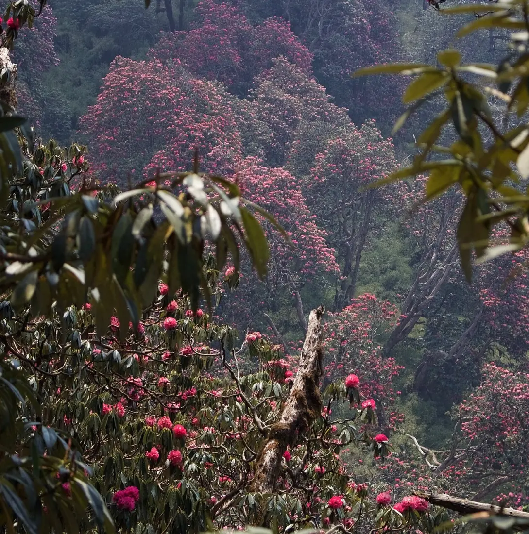
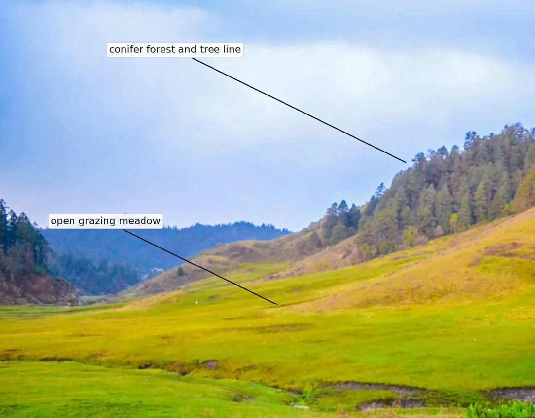
Problem. The mean March temperature at Hetauda (altitude 400 m) is 26 °C. A student walks from Hetauda up to Daman (altitude 2,300 m). Taking the lapse rate as 6 °C per 1,000 m, estimate the temperature at Daman, and name the vegetation zones crossed on the way.
Solution. The gain in height is
The fall in temperature is the lapse rate multiplied by the height gained:
The walk starts at 400 m in the tropical zone (Sal forest), crosses 1,000 m into the subtropical zone (chir pine and chilaune–katus) and ends at 2,300 m in the temperate zone (oak and rhododendron). Three zones in one day's walk.
The flora of Nepal in numbers
| Group | Species recorded in Nepal |
|---|---|
| Flowering plants (angiosperms) | about 5,600 |
| Gymnosperms | 26 |
| Pteridophytes (ferns and allies) | 583 |
| Bryophytes | 1,217 |
| Lichens | 1,086 |
| Fungi | 2,470 |
| Algae | 1,101 |
| Endemic flowering plants (found nowhere else) | 348 |
Figures: Department of Plant Resources, 2025. Orchidaceae is the largest family, with about 500 orchid species; Nepal has roughly 30 species of Rhododendron, of which Rhododendron arboreum (lali gurans) is the national flower. Forest covers 43.4 % of the country, and forest together with other wooded land covers 46.1 % (Forest Research and Training Centre, 2024) — second only to Bhutan in South Asia.
In-situ conservation
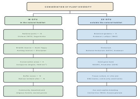
In-situ conservation is the protection of species inside their natural habitat, by protecting the habitat itself — national parks, reserves, conservation areas, community forests. Ex-situ conservation is the protection of species outside their natural habitat, in botanical gardens, gene banks, herbaria, tissue-culture laboratories and zoos.
In-situ conservation is the stronger method, because it saves not one species but the whole community it belongs to, and the species keeps evolving in the conditions it is adapted to. Nepal's legal instrument is the National Parks and Wildlife Conservation Act, 1973 (2029 BS), which created the first protected area, Chitwan National Park, in 1973.
| Category | Number | Examples and notes |
|---|---|---|
| National parks | 13 | Chitwan (1973, the first, and a natural World Heritage Site since 1984); Sagarmatha (1976, World Heritage 1979); Langtang; Rara (106 km², the smallest); Shey Phoksundo (the largest park); Khaptad; Bardiya; Makalu Barun; Shivapuri Nagarjun; Banke (2010); Shuklaphanta and Parsa (upgraded from reserves in 2017); Chhayanath, Mugu (2025) |
| Wildlife reserve | 1 | Koshi Tappu (1976), Sunsari–Saptari–Udayapur — the last home of the wild buffalo (arna) |
| Hunting reserve | 1 | Dhorpatan (1987), Baglung–Myagdi–Rukum — the only reserve where licensed hunting is allowed |
| Conservation areas | 6 | Annapurna (1992; 7,629 km², the largest protected area in Nepal), Kanchenjunga, Manaslu, Gaurishankar, Api Nampa, and Krishnasar (Blackbuck) in Bardiya — at 16.95 km² the smallest |
| Buffer zones | 13 | Declared around parks and reserves; 30–50 % of the park's income is returned to buffer-zone communities |
| Ramsar (wetland) sites | 10 | Koshi Tappu (1987, the first), Beeshazari Tal, Ghodaghodi Tal, Jagdishpur reservoir, Rara, Phoksundo, Gosaikunda, Gokyo, Mai Pokhari, and the Lake Cluster of Pokhara Valley (2016, the largest) |
Together the protected areas cover about 34,420 km², roughly 23.4 % of Nepal's land area — one of the highest proportions in Asia. Outside them, community forestry does the same work by another route: about 23,000 community forest user groups (CFUGs) manage some 2.5 million hectares, close to 39 % of the national forest, on behalf of more than three million households. Religious forests, leasehold forests for poor households, and the sacred groves around temples and deurali resting places add to the total.
Older textbooks and the department's own website still say 12 national parks and 20 protected areas. Chhayanath National Park (Mugu) was declared in 2025 by splitting off part of Shey Phoksundo, so the number of parks rose to 13 and the total to 21 while the total protected area hardly changed. Either count is accepted in the exam provided you name the parks correctly — the marks are for the names and the categories, not for the total.
Ex-situ conservation
Ex-situ methods are the back-up. They matter most for species already too rare to survive in the wild, for crop varieties that farmers have stopped growing, and for keeping material available to researchers and breeders.
| Facility | Where | What it conserves |
|---|---|---|
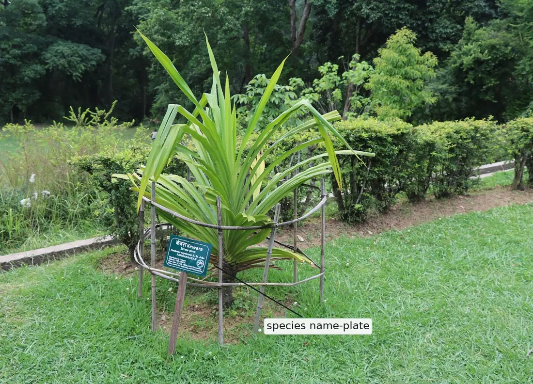
| National Botanical Garden (est. 1962, 82 ha) | Godawari, Lalitpur | Over 1,285 living plant species in about 30 themed gardens; one of 11 botanical gardens run by the Department of Plant Resources, from Ilam in the east to Kailali in the west |
| National Herbarium and Plant Laboratories (KATH) (est. 1961) | Godawari, Lalitpur | About 170,000 dried, mounted and named herbarium specimens — the reference collection against which any Nepali plant is identified |
| National Gene Bank — National Agriculture Genetic Resources Centre, NARC (est. 2010) | Khumaltar, Lalitpur | About 11,800 seed accessions of more than 330 crop species stored at −20 °C, plus a field gene bank, an in-vitro (tissue-culture) bank and a DNA bank |
| Community seed banks (first at Dalchowki, Lalitpur, 1994) | About 54 across the country | Local landraces of rice, maize, millet and beans, kept and exchanged by farmers themselves |
| Central Zoo (est. 1932, about 6 ha; run by NTNC since 1995) | Jawalakhel, Lalitpur | Nepal's only zoo — roughly 1,300 animals of about 120 species, and a rescue centre |
| Gharial Breeding Centre (est. 1978) | Kasara, Chitwan | Captive breeding of the gharial crocodile; over 1,800 juveniles released into Nepal's rivers |
Answering "differentiate in-situ and ex-situ conservation"
Draw a two-column table and fill four rows: (i) where the organism is kept; (ii) whether the whole ecosystem is conserved; (iii) whether evolution continues; (iv) cost and number of individuals possible. Then give two named Nepali examples of each. A pair of examples is usually worth a mark on its own.
Problem. Nepal's protected areas cover 34,420 km² and its total land area is 147,181 km². Forest covers 43.4 % of the country. Calculate (a) the percentage of Nepal that is protected, and (b) the area of Nepal under forest, in km² and in hectares.
Solution.
(a) Percentage protected:
(b) Forest area:
One square kilometre is 100 hectares, so
About 6.4 million hectares of Nepal is forest, and just under a quarter of the country is inside a protected area.
Problem. About 23,000 community forest user groups manage 2.5 million hectares of Nepal's forest. Taking the national forest area as 6.4 million hectares, find (a) the average area handed to one user group, and (b) the percentage of Nepal's forest that is community-managed.
Solution.
(a) Average area per group:
(b) Share of the national forest:
So a typical community forest is only about 109 hectares — roughly a square kilometre — yet together these small patches make up nearly two-fifths of Nepal's forest. That is why community forestry, not the protected-area system, is what most Nepali villagers actually experience as conservation.
5.2 Natural environment, vegetation and human activities
Vegetation sits between the physical environment and the people who live in it, and the influence runs in all three directions.
What people take from vegetation
Firewood is still the main cooking fuel in most rural Nepali households. Forests also supply timber, fodder for stall-fed cattle, leaf litter that becomes compost for the fields, bamboo, and non-timber forest products (NTFPs) — Swertia chirayita (chiraito), Nardostachys jatamansi (jatamansi), Zanthoxylum armatum (timur), Cinnamomum tamala (tejpat) and yarsagumba, which together earn rural households a large cash income. Beyond the products, vegetation holds soil on steep slopes, slows monsoon runoff, recharges springs, stores carbon, and brings the trekkers whose money supports whole districts.
How human activities damage vegetation
| Activity | What it does |
|---|---|
| Deforestation and encroachment | Clearing for settlement, roads and cropland; worst in the Terai and inner Terai after malaria control opened them to settlement in the 1950s and 60s |
| Shifting cultivation (khoriya) | Slash-and-burn on hill slopes in the east; the fallow period is now too short for the forest to recover |
| Overgrazing | Too many cattle, goats and sheep on the same pasture; seedlings are eaten before they can establish, and alpine meadows are worn to bare soil |
| Forest fire | Deliberate pre-monsoon burning (March–May) to bring on fresh grass; it kills regeneration and dries the soil |
| Lopping and illegal felling | Repeated lopping of Sal and oak for fodder and fuel leaves stunted, hollow trees |
| Over-collection of NTFPs | Yarsagumba, panchaunle and jatamansi are dug up before they can set seed |
| Quarrying and road building in the Chure | Sand, gravel and boulder extraction destabilises the Chure, which is the recharge zone for Terai groundwater |
| Invasive alien species | Mikania micrantha smothers Sal regeneration in Chitwan; Eichhornia crassipes (water hyacinth) blankets Phewa Tal; Lantana camara, Chromolaena odorata and Parthenium hysterophorus take over grazing land |
| Pollution and infrastructure | Brick kilns, cement dust, hydropower reservoirs and transmission lines |
The consequences are visible: soil erosion and landslides, sheet flooding when the Chure rivers spill onto the Terai, a falling Terai water table, the loss of species before they are even described, and an upward shift of the tree line as the climate warms.
What is being done
- Community forestry — handing national forest to local user groups. Forest cover in the mid-hills has increased measurably since the 1990s, the clearest conservation success Nepal has had.
- Leasehold forestry for poor households, and agroforestry — growing fodder and fruit trees on private land so that pressure on the forest falls.
- Protected areas and buffer zones, with revenue sharing so that local people gain from conservation rather than lose by it.
- The President Chure–Terai Madhesh Conservation Programme, which bans riverbed mining in sensitive stretches and restores degraded Chure catchments.
- Alternative energy — biogas plants, improved cooking stoves, micro-hydro and LPG reduce firewood demand.
- Law. The Forest Act, 2019 (2076 BS) protects named species. Two are banned outright from collection, sale, transport and export — Dactylorhiza hatagirea (panchaunle) and the bark of Juglans regia (okhar). Seven, including Abies spectabilis, Nardostachys jatamansi, Taxus spp. and Rauvolfia serpentina, may not be exported unprocessed. Four trees — Shorea robusta, Dalbergia latifolia (satisal), Pterocarpus marsupium (bijayasal) and Juglans regia — may not be felled or transported for commercial purposes.
Preservation locks people out. Conservation manages use so that the resource survives — a community forest that supplies firewood every year and still grows thicker is being conserved, not preserved. NEB answers that describe conservation as "stopping all use of the forest" lose marks.
Chapter summary
- Vegetation is the plant cover of an area; flora is the list of species in it. Nepal holds about 3.2 % of world flora on under 0.1 % of world land.
- Temperature falls about 6 °C per 1000 m, which produces six altitudinal zones: Tropical (<1000 m, Sal), Subtropical (1000–2000 m, chilaune–katus and chir pine), Temperate (2000–3000 m, oak and rhododendron), Subalpine (3000–4000 m, fir and birch), Alpine (4000–5000 m, scrub and meadow) and Nival (>5000 m, snow).
- The tree line lies near 4000 m. Behind the Himalaya, the trans-Himalayan steppe of Mustang, Manang and Dolpa gets only about 250 mm of rain and carries Caragana, Artemisia and Hippophae.
- In-situ conservation protects the habitat: 13 national parks, 1 wildlife reserve (Koshi Tappu), 1 hunting reserve (Dhorpatan), 6 conservation areas, 13 buffer zones and 10 Ramsar sites — about 23.4 % of the country. Chitwan (1973) was the first; Annapurna (1992) is the largest.
- Ex-situ conservation protects the organism away from its habitat: the National Botanical Garden at Godawari (1962), the National Herbarium (KATH), the National Gene Bank at Khumaltar (2010), community seed banks, and the Central Zoo, Jawalakhel (1932).
- About 23,000 CFUGs manage 2.5 million ha, nearly 39 % of Nepal's forest. Forest covers 43.4 % of the country.
- Vegetation is damaged by deforestation, khoriya, overgrazing, fire, over-collection of NTFPs, Chure quarrying and invasive species such as Mikania micrantha and Eichhornia crassipes; it is repaired by community forestry, agroforestry, buffer-zone sharing, alternative energy and the Forest Act, 2019.
Practice questions
Group A — Multiple choice (1 mark each)
- The altitudinal range of the temperate vegetation zone of Nepal is [1]abelow 1000 mb1000–2000 mc2000–3000 md3000–4000 m
- Shorea robusta is the dominant tree of the [1]atropical zonebsubtropical zonectemperate zonedsubalpine zone
- The first national park of Nepal, established in 1973, is [1]aSagarmathabLangtangcChitwandRara
- The National Gene Bank of Nepal is located at [1]aGodawaribKhumaltarcJawalakheldKasara
- Betula utilis (bhojpatra) is characteristic of the [1]atropical zonebtemperate zonecsubalpine zonednival zone
- Conservation of a species in a botanical garden is an example of [1]ain-situ conservationbex-situ conservationcbuffer zone managementdcommunity forestry
Answers to Group A
1. (c) — the temperate belt runs from 2000 m to 3000 m, the oak–rhododendron zone.
2. (a) — Sal is the dominant tree of the Terai, Bhabar and Dun valleys, below 1000 m.
3. (c) — Chitwan, 1973; Sagarmatha, Langtang and Rara followed in 1976.
4. (b) — the National Agriculture Genetic Resources Centre, NARC, Khumaltar, Lalitpur.
5. (c) — Himalayan birch forms near-pure belts from about 3300 m to the tree line.
6. (b) — the plant is kept outside its natural habitat, so it is ex-situ.
Group B — Short answer (4 marks each)
- Name the six altitudinal vegetation zones of Nepal with their altitude ranges, and give one indicator species of each. [4]
- Differentiate between in-situ and ex-situ conservation, giving two named Nepali examples of each. [4]
- The mean annual temperature at Pokhara (altitude 820 m) is 20 °C. Using a lapse rate of 6 °C per 1000 m, estimate the temperature at Ghorepani (2,870 m), and name the vegetation zone and the indicator tree species you would expect to find there. [4]
- List any four human activities that degrade the vegetation of Nepal, and state one control measure for each. [4]
Answers to Group B
1. Tropical, below 1000 m — Shorea robusta. Subtropical, 1000–2000 m — Schima wallichii or Pinus roxburghii. Temperate, 2000–3000 m — Quercus semecarpifolia or Rhododendron arboreum. Subalpine, 3000–4000 m — Abies spectabilis or Betula utilis. Alpine, 4000–5000 m — Rhododendron anthopogon with Kobresia meadow. Nival, above 5000 m — mosses and lichens only.
2. In-situ = conserved inside the natural habitat, so the whole ecosystem is saved and the species keeps evolving; cheap per species but needs large areas. Examples: Chitwan National Park, Koshi Tappu Wildlife Reserve. Ex-situ = conserved outside the natural habitat, under human care; useful for species too rare to survive in the wild, but expensive and only a few individuals can be held. Examples: National Botanical Garden, Godawari; National Gene Bank, Khumaltar (or the Central Zoo, Jawalakhel).
3. Height gained = 2870 - 820 = 2050\ \text{m}. Temperature fall = 6 \times 2050/1000 = 12.3\ ^\circ\text{C}, so T = 20 - 12.3 = 7.7\ ^\circ\text{C}. At 2,870 m Ghorepani lies in the temperate zone, where the expected species are Quercus semecarpifolia (khasru), Rhododendron arboreum (lali gurans) and Pinus wallichiana (gobre salla).
4. (i) Deforestation and encroachment — hand the forest to community forest user groups and register boundaries. (ii) Overgrazing — fix a stocking limit and rotate the kharka, and promote stall feeding on fodder trees. (iii) Forest fire — build fire lines, train community fire-fighting groups and ban pre-monsoon burning. (iv) Over-collection of NTFPs such as yarsagumba — issue harvesting permits with a closed season, and cultivate the species instead of digging it from the wild. (A fifth: invasive species such as Mikania micrantha — manual uprooting before flowering and replanting with native species.)
Group C — Long answer (8 marks each)
- Describe the types of vegetation found in Nepal from the Terai to the snow line, with a labelled diagram showing altitude, and explain why so many vegetation types occur in such a small country. [8]
- (a) Define in-situ and ex-situ conservation. [2](b) Describe the protected area system of Nepal, naming the categories, their numbers and one example of each. [4](c) Describe any two ex-situ conservation facilities of Nepal, stating where each is and what it conserves. [2]
Answer outline to Group C question 1
Diagram: the altitude profile of this chapter — a rising transect from Terai to High Himal with horizontal bands at 1000, 2000, 3000, 4000 and 5000 m, each band named and given two indicator species, and the tree line marked at about 4000 m.
Points to make: (i) Tropical below 1000 m — Sal forest of Shorea robusta with Terminalia alata, khair–sissoo riverine forest of Acacia catechu and Dalbergia sissoo, and Saccharum grassland; Terai, Bhabar and Dun valleys. (ii) Subtropical 1000–2000 m — Schima wallichii with Castanopsis indica, chir pine Pinus roxburghii on dry south slopes, Alnus nepalensis on stream banks; the Mahabharat midlands. (iii) Temperate 2000–3000 m — oak Quercus semecarpifolia with Rhododendron arboreum, blue pine Pinus wallichiana, Tsuga dumosa. (iv) Subalpine 3000–4000 m — silver fir Abies spectabilis and birch Betula utilis with Rhododendron campanulatum. (v) Alpine 4000–5000 m — treeless scrub of Rhododendron anthopogon and Juniperus, and Kobresia meadows grazed in summer. (vi) Nival above 5000 m — snow and rock, mosses and lichens only. (vii) The trans-Himalayan cold desert of Mustang, Manang and Dolpa, with about 250 mm of rain, Caragana, Artemisia and Hippophae.
Why so many: the land rises from 59 m to 8,848 m within 193 km, so temperature falls about 6 °C per 1000 m and produces belt after belt; the monsoon makes the east wetter than the west; aspect separates dry south-facing from moist north-facing slopes; and the Himalaya casts a rain shadow that creates a cold desert on its northern side. Nepal therefore carries tropical and arctic vegetation in the same country.
Practise more: Biology question bank