Unit 20 · Compulsory Mathematics · 14 min read
Bearing and Scale Drawing
What the syllabus asks for 3
- bearing and its measurement
- drawing and reading a scale drawing
- distance and direction problems using bearing
A bearing is a way of writing a direction as a single number, so that there is no argument about what "north-east" means. A scale drawing is a way of putting several such directions and distances on one sheet of paper, to scale. Together they are the mathematics of a trekking route, a flight path and a surveyor's notebook.
You should be able to write and read a three-figure bearing, find the back bearing, draw a scale drawing from a description of distances and bearings, and measure a distance or a bearing from a drawing.
20.1 Bearing
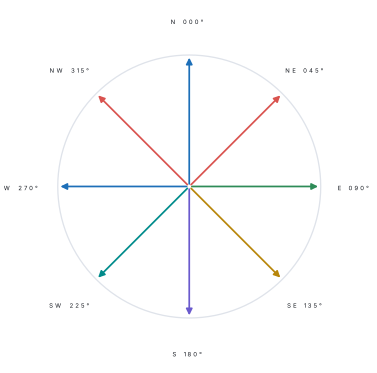
A bearing is the angle measured clockwise from north, written with three figures. So 060° means 60° clockwise from north, and 275° means 275° clockwise from north.
Because a bearing is measured from north and is always positive, it carries the direction without any words.
| Direction | Bearing | Why |
|---|---|---|
| North | 000° | at the start of the turn |
| East | 090° | a quarter turn clockwise |
| South | 180° | a half turn |
| West | 270° | three quarters |
| North-east | 045° | halfway between north and east |
| South-west | 225° | halfway between south and west |
Three figures are written even for small angles: north is 000°, not 0°, and 8° is 008°. Writing three figures is a convention that stops 8° being confused with 80°.
A bearing is the angle, measured clockwise from the north line, from one point to another. It is always given in three figures, from 000° to 360°.
Problem. Write as bearings: (a) due west, (b) 30° east of north, (c) 40° west of south.
Solution. (a) West is three quarters of a turn clockwise from north, so 270°.
(b) 30° east of north means starting at north and turning 30° towards the east, i.e. clockwise: 030°.
(c) From south, turning towards the west means turning further clockwise. South is 180°, and 40° more gives 220°.
Check. (c) is between south (180°) and west (270°), which is right for a south-westerly direction ✓. If you had measured anticlockwise from south you would have written 140°, which points south-east — the opposite side.
20.1.1 Back bearing
The back bearing is the bearing from the second point back to the first. It is found by adding 180° if the bearing is less than 180°, and subtracting 180° if it is more.
Why ±180°? Let the bearing of S from R be \theta. The north lines at R and S are parallel and RS is a transversal, so the angles \angle N_1RS and \angle N_2SR are co-interior and add to 180°. Measuring clockwise from north at S, the bearing of R from S is 360°-\angle N_2SR=360°-(180°-\theta)=\theta+180° (subtract 360° if this is more than 360°).
Problem. A village B is on a bearing of 065° from village A. Find the bearing of A from B.
Solution. 065° is less than 180°, so add 180°:
Answer. 245°.
Check. The two directions must point exactly opposite each other, and 245° is 180° round from 065° ✓. The distances are the same in both directions, so only the direction changes.
Problem. Q is on a bearing of 300° from P. Find the bearing of P from Q.
Solution. 300° is more than 180°, so subtract 180°: 300-180=120°.
Answer. 120°.
Check. 120+180=300 ✓. The rule works in both directions.
20.2 Scale drawing
A scale drawing is a drawing in which every length on the paper is a fixed fraction of the real length. The fraction is the scale, written as a ratio such as 1:50\,000 ("1 cm on the paper represents 50 000 cm on the ground") or in words such as "1 cm to 1 km".
Keep one unit throughout: convert the real distance to the same unit as the drawing before dividing.
| Real distance | Scale | Drawing length |
|---|---|---|
| 5 km | 1 cm to 1 km | 5 cm |
| 2 500 m | 1 cm to 500 m | 5 cm |
| 60 km | 1:1\,000\,000 | 6 cm |
Problem. The distance between two towns is 24 km. On a map of scale 1:400\,000, how far apart are they?
Solution. The scale means 1 cm on the map is 400 000 cm on the ground.
So 1 cm represents 4 km, and 24 km is represented by
Answer. 6 cm.
Check. 6\ \text{cm}\times400\,000=2\,400\,000 cm =24 km ✓.
20.2.1 Drawing a route from bearings
Method.
- Choose a scale that will fit the page, and write it on the drawing.
- Mark the starting point and draw a north line through it.
- Measure the first bearing clockwise from the north line with a protractor, and draw the first leg to the correct scaled length.
- At the end of that leg, draw a NEW north line (parallel to the first) and measure the next bearing from it. Every leg gets its own north line.
- Join the finishing point to the start to find the direct distance and its bearing.
A bearing is measured from north at the point you are standing on. At each new point the north line is a fresh parallel line, not the same line carried along. Measuring the second bearing from the first north line gives a route that curves away from the truth by whatever angle the first leg turned through.
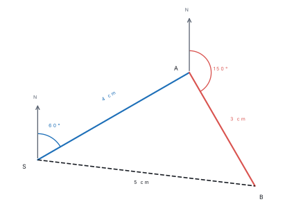
Problem. A plane flies 200 km on a bearing of 060° and then 150 km on a bearing of 150°. Using a scale of 1 cm to 50 km, draw the route, and measure the distance and the bearing of the finishing point from the start.
Solution. Scale. 1 cm to 50 km, so 200 km is 4 cm and 150 km is 3 cm.
Drawing. Mark the start S and a north line. Measure 60° clockwise and draw SA=4 cm. At A draw a fresh north line, measure 150° clockwise from it and draw AB=3 cm. Join B back to S.
Measuring. SB measures about 5.0 cm, and the bearing of B from S (measured clockwise from the north line at S) is about 097°. In real terms, 5.0\times50=250 km.
Answer. About 250 km on a bearing of about 097° from the start.
Check. The two legs turn through 150°-60°=90°, so the triangle SAB has a right angle at A. By Pythagoras, SB=\sqrt{200^2+150^2}=\sqrt{62\,500}=250 km ✓. The bearing 097° lies between 060° and 150°, as it must.
In a scale-drawing question, an answer within about 1° or 2° of the true bearing and within a millimetre or two of the true length is accepted. What is marked is whether the north lines are drawn, whether the protractor was used at the right point, and whether the scale is stated. Write the scale on the drawing; it is worth a mark on its own.
20.3 Bearings on the compass rose
A bearing is always measured clockwise from north and written with three figures: 045°, not 45°.
| Idea | Rule | Example |
|---|---|---|
| Bearing | clockwise from north, three figures | due east = 090° |
| Back bearing | add 180° (subtract if the sum exceeds 360°) | bearing 070° \to back bearing 250° |
| Scale as a ratio | 1 : n means 1 unit on the map is n units on the ground | 1 : 50{,}000 |
| Map to ground | ground = map length \times n | 4 cm on 1:25{,}000 = 1 km |
| Ground to map | map = ground length \div n | 3 km on 1:50{,}000 = 6 cm |
Question. A village B lies on a bearing of 130° from A. What is the bearing of A from B?
Answer. Back bearing = 130° + 180° = \textbf{310°}. (If the first bearing had been more than 180°, we would subtract instead: the back bearing of 250° is 250° - 180° = 070°.)
Question. On a map of scale 1:40{,}000, two towns are 6.5 cm apart. Find the real distance in kilometres. How far apart would they be on a 1:25{,}000 map?
Answer. Real distance = 6.5 \times 40{,}000 = 260{,}000 cm = \textbf{2.6 km}. On the 1:25{,}000 map: \frac{260000}{25000} = \textbf{10.4 cm} — a larger scale gives a bigger picture of the same ground.
Pace out the route from your home to school, counting paces for each straight stretch and noting the bearing at each turn with a compass (or a compass app). Then draw the route to a scale of 1 cm to 50 m, marking each bearing. Check: measure the straight-line distance on your drawing and convert it back to metres. How does it compare with the distance you actually walk?
Chapter summary
- A bearing is measured clockwise from north and written in three figures, from 000° to 360°.
- North 000°, east 090°, south 180°, west 270°.
- The back bearing is the bearing ± 180°: add 180° if the bearing is under 180°, subtract 180° if it is over.
- \text{scale}=\frac{\text{drawing length}}{\text{real length}}, and one unit must be used throughout.
- In a scale drawing a fresh north line is drawn at every point before the next bearing is measured.
- State the scale on the drawing; it earns a mark and it makes the drawing readable.
Practice questions
Group A — Objective (1 mark each)
- The bearing of east is [1]a000°b090°c180°d270°
- The bearing of north-west is [1]a045°b135°c225°d315°
- Bearings are measured from [1]aeast, clockwisebnorth, clockwisecnorth, anticlockwisedsouth, clockwise
- The back bearing of 070° is [1]a110°b250°c290°d160°
- On a scale of 1 cm to 2 km, 10 km is drawn as [1]a2 cmb5 cmc10 cmd20 cm
- A bearing of 8° should be written as [1]a8°b080°c008°d800°
Answers to Group A
1. (b) — a quarter turn clockwise from north.
2. (d) — north-west is halfway between north (000°) and west (270°), so 315°.
3. (b) — from north, clockwise.
4. (b) — 70+180=250.
5. (b) — 10\div2=5.
6. (c) — three figures.
Group B — Short answer (2 marks each)
- Write the bearings of south-east and of 25° west of north. [2]
- The bearing of B from A is 130°. Find the bearing of A from B. [2]
- On a map of scale 1:200\,000, two places are 7 cm apart. Find the real distance in kilometres. [2]
- A walker goes 6 km north and then 8 km east. Find his distance and bearing from the start. [2]
Answers to Group B
1. South-east is 135°; 25° west of north is 360-25=335°.
2. 130+180=310°.
3. 7\times200\,000=1\,400\,000 cm =14 km.
4. The two legs are at right angles, so distance =\sqrt{6^2+8^2}=10 km. From a scale drawing (say 1 cm to 1 km), the protractor gives a bearing of about 053°.
Group C — Long answer (4 marks each)
- A ship sails 120 km on a bearing of 090° and then 160 km on a bearing of 180°. Using a scale of 1 cm to 20 km, draw the route and find the distance and bearing of the ship's final position from its starting point. [4]
- Madhav walks 5 km on a bearing of 030° from A to B, then 3 km on a bearing of 140° from B to C, and then returns straight to A. Make a scale drawing (1 cm to 1 km), and find the distance CA and the bearing of A from C. [4]
Answers to Group C
1. Scale. 1 cm to 20 km, so 120 km is 6 cm and 160 km is 8 cm. Drawing. From the start S draw a north line, turn 090° (due east) and draw SA=6 cm. At A draw a fresh north line, turn 180° (due south) and draw AB=8 cm. Join B to S. Distance. The angle at A is 90°, so SB=\sqrt{6^2+8^2}=10 cm on the drawing, i.e. 10\times20=200 km. Bearing. The protractor at S gives about 143°. Check. B is east and south of S, so its bearing must lie between 090° and 180° ✓.
2. Scale. 5 km → 5 cm, 3 km → 3 cm. Draw the north line at A, turn 030° and draw AB = 5 cm; at B draw a new north line, turn 140° and draw BC = 3 cm; join CA. Measurements. CA ≈ 4.9 cm, so the actual distance is about 4.9 km. At C draw a north line; the bearing of A from C measures about 245°. Check. A lies to the south-west of C, so the bearing must be between 180° and 270° ✓; and CA must be less than 5+3=8 km ✓.
Extra practice
Group B (2 marks)
11. Write the bearing of due south-west and its back bearing.
12. On a 1:20{,}000 map, how long is a 3 km road?
Group C (4 marks)
13. A boat sails 8 km on a bearing of 090°, then 6 km on a bearing of 000°. Draw a rough sketch, and find its distance from the starting point.
Extra practice — answers
11. South-west = 225°; back bearing = 225° - 180° = 045°.
12. 3 km = 300{,}000 cm; map length = \frac{300000}{20000} = 15 cm.
13. The two legs are at right angles (east then north), so the path forms a right-angled triangle with legs 8 km and 6 km. Distance = \sqrt{8^2 + 6^2} = \sqrt{64 + 36} = \sqrt{100} = \textbf{10 km} from the start.
Objective practice
Choose the correct answer. [5×1=5]
1. The bearing of due north is written as (a) 0° (b) 000° (c) 360° only (d) 090°
2. The back bearing of 065° is (a) 115° (b) 245° (c) 295° (d) 025°
3. On a map of scale 1:50{,}000, 4 cm represents (a) 200 m (b) 2 km (c) 20 km (d) 50 km
4. A bearing is always measured (a) anticlockwise from north (b) clockwise from north (c) clockwise from east (d) from the nearest road
5. A distance of 7.5 km on a 1:25{,}000 map is (a) 3 cm (b) 15 cm (c) 30 cm (d) 75 cm
Objective practice — answers
1. (b) — bearings use three figures.
2. (b) — 065° + 180° = 245°.
3. (b) — 4 \times 50{,}000 = 200{,}000 cm = 2 km.
4. (b) — clockwise from north.
5. (c) — 750{,}000 \div 25{,}000 = 30 cm.
Practise more: Mathematics question bank